2013年4月21日 星期日

轉貼「利用Google Earth還原小林埋村災害始末」

經由 Google Map/Earth觀察報@Sinica 廖泫銘 著 (日期為 2013/4/21)

潘國樑等人(2011)發表一篇學術文章:「小林埋村事件之還原—衛星影像判釋」航測及遙測學刊,16(1):63-78。
以下圖文摘錄自該論文:
小林土石流發生後之地形分區圖
小林土石流發生後之地形分區圖
該研究所使用Google Earth上的衛星影像,取其具有多期影像的優點,容易立即轉換,極便於比較不同時間的地貌變化( Change Detection ), 同時又可輕易的進行影像縮放(Zoom-in and Zoom-out),在影像上還可快速的追蹤、區劃(Zonation)及註解。由於Google Earth 提供之小林村災後遙測影像距離災後時間點並不遙遠,而災後整體地形大致上未被人為破壞,且影像上之植生尚未復育,因此針對Google Earth所提供的災後影像,以人為方式進行判釋微地形的變化情形,進而推敲出小林村災害發生之始末。總體言之,Google Earth 在地理位置的精確度、地貌表現的忠實度,以及影像的可判釋力等還是值得信賴的。
如果將小林土石流的地形分區套疊在災前的衛星影像上時,可以發現其與原有地形非常吻合。由此證明,大規模地質災害大多在原地一再重現。因此利用衛星影像快速的檢出古土石流或古深層滑動,並且採取規避或棄離的措施,將可預防小林式埋村悲劇再度重演。
轉貼至個人Facebook轉貼至個人Facebook

您可以在這裡操作的事項:

2013年4月8日 星期一

轉貼「Mapping History - Historical Patterns Animated」

Mapping History - Historical Patterns Animated
Free Technology for Teachers

Some of my favorite social studies lesson plans included having students use maps to analyze data and identify patterns in history. Over the years I've done this with paper maps and digital maps. This afternoon I found a good site, produced by the University of Oregon that features lots of animated maps illustrating problems, patterns, and events throughout history. Mapping History is essentially a digital atlas of American, European, Latin American, and African history. Each section is divided into modules based on historical themes and eras.

Applications for Education
Mapping History is a resource that I have bookmarked for reference the next time that I need a thematic map to illustrate a pattern in history. I found that some of the maps will also be useful as question prompts. For example, this map prompts students to evaluate the extent to which the expansion of slavery in the U.S. was connected to the demand for cotton.


This post originally appeared on Free Technology for Teachers .


Original Article: http://feedproxy.google.com/~r/freetech4teachers/cGEY/~3/7Gc5p0YLJmE/mapping-history-historical-patterns.html


從我的 iPad 傳送

2013年3月28日 星期四

轉貼「Google Maps Engine Lite 用免費Google地圖引擎自製地圖」

資料來源:

電腦玩物

Google Maps Engine Lite 用免費Google地圖引擎自製地圖:
Google Maps Engine Lite
Google Maps Engine 」是 Google 針對企業需求所提供的付費地圖製作引擎,可以讓有商業需求的客戶自製出像是犯罪地圖、氣候變遷地圖,或是大型的城鎮建設計劃地圖等等。而今天開始 Google 推出了針對一般用戶的「 Google Maps Engine Lite 」,功能較少,但開放給非商業用途需求免費使用。
「 Google Maps Engine Lite 」讓你在 Google 衛星、地形、街道地圖的基礎上,重新打造自己需要的新地圖,可以自行擺放各種地標、路線,能夠利用表格重建或自由編輯每個地標的資料。最後,還能和團隊夥伴協同合作。
因為是針對非商業用途,所以可能在使用上比較適合像是:學校的旅行計畫、非營利組織的地理資料報告( Google 舉的例子是製作沿岸鯊魚出沒地圖),或者親朋好友之間的聯絡資料分享,以及志同道合同好的某些與地點相關的資訊協同合作(例如登山路線、溜狗地圖)。


你可能會問,這和之前 Google 地圖內的「我的地圖」功能有什麼不同?
在自製地圖的細節上,「 Google Maps Engine Lite 」提供了乾淨的多種地圖圖層給用戶使用,不像「我的地圖」那樣還有許多原本 Google 地圖的店家景點資訊夾雜在其中。另外,「 Google Maps Engine Lite 」也提供了更多「自訂地理資料欄位」的設定。
而且「 Google Maps Engine Lite 」具備了真正的協同合作、多人編輯功能。做好的地圖大概就像是下面這樣(下面嵌入的地圖,不確定是否所有瀏覽器都能順利開啟):


「 Google Maps Engine Lite 」的自製地圖流程對於一般用戶來說也非常好上手,下面我就以製作一份「澳門旅遊計畫」來做個簡單示範
首先進入「 Google Maps Engine Lite 」,建立一份新地圖,之後你也可以針對已經建立的地圖進行修改、刪除。
Google Maps Engine Lite-02

在建立新的地圖,或是新增同一個地圖內的不同圖層時,都可以匯入你之前在「 我的地圖 」裡建立的資料。
Google 提到未來「我的地圖」功能也會整併到「 Google Maps Engine Lite 」當中。
Google Maps Engine Lite-03

你可以利用「 Google Maps Engine Lite 」提供的地標、路線工具,在地圖上自訂需要的地點,使用方式就是新增、拖曳等等基本操作而已。
Google Maps Engine Lite-04

當然,你可以透過搜尋,直接找出你需要的地址或是地點位置,然後把他們新增到你的自製地圖終。
Google Maps Engine Lite-05

置放好地標大頭針後,還能調整大頭針的顏色與樣式,甚至替換更多不同的標註圖示。
Google Maps Engine Lite-06

在「 Google Maps Engine Lite 」中,雖然只是免費版,但已經提供了很豐富的地標圖示給用戶使用。
Google Maps Engine Lite-07

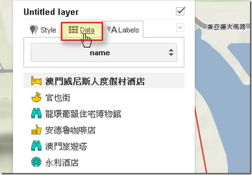
接著,「 Google Maps Engine Lite 」提供了很方便的表格模式來讓用戶快速編輯地點資料。
先切換到〔 Data 〕分頁。
Google Maps Engine Lite-08

這時候會彈出你所有已放置地標的資料表格,你可以透過表格直接編輯地點的資料。
Google Maps Engine Lite-09

而且這份表格是可以讓你自己新增、刪減欄位的,例如旅遊地圖中可能需要標明遊玩的停留時間,那麼就可以自己新增這個欄位。
Google Maps Engine Lite-10

而這些經由表格快速編輯完成的地點資料,都可以在地圖上以氣泡框快速查詢。
Google Maps Engine Lite-11

另外在地圖的底層上,「 Google Maps Engine Lite 」也提供了像是衛星地圖、地形圖、街道圖等等不同的選擇。
Google Maps Engine Lite-12

你可以把自製的地圖分享給指定的用戶,或是邀情其他夥伴一起來編輯同一份自製地圖。
如果你有編輯地圖的需求,那麼現在可以立刻試試看免費的「 Google Maps Engine Lite 」。
Google Maps Engine Lite-13
喜歡這篇文章嗎?歡迎追蹤我的FacebookTwitterGoogle+,獲得更多有趣、實用的數位科技消息,更歡迎直接透過社群聯繫我。

2013年3月24日 星期日

轉貼「海平面上升影響地圖」

海平面上升影響地圖
Google Map/Earth觀察報@Sinica

The HeyWhatsThat Map Layers網站利用Google地圖呈現全球海平面上升影響地圖,同時還可以加入等高線及土地利用圖層,使用者可以自訂海平面上升高度及
等高線間隔高度。

heywhatsthat.

轉貼至個人Facebook轉貼至個人Facebook


Original Article: http://gis.rchss.sinica.edu.tw/google/?p=4630


從我的 iPad 傳送

2013年3月20日 星期三

轉貼National Geographic Explains Fracking

美國近來積極開發油頁岩,「free technology for teachers」提供了一段由美國國家地理雜誌製作的短片,說明了頁岩油的抽取方式。

National Geographic Explains Fracking:
Last fall I drove across North Dakota and I'm going back next month to deliver a keynote for NDATL's annual conference. Because North Dakota is on my mind National Geographic grabbed my attention with a headline this month about shale oil and fracking in North Dakota. Even though it is a bit robotic, the National Geographic video below does a good job of illustrating the process without putting too much bias into the explanation.


This post originally appeared on Free Technology for Teachers
.

轉貼Three Quick Resources About How Maple Syrup Is Made

Three Quick Resources About How Maple Syrup Is Made
Free Technology for Teachers

Today is the first day of Spring in the Northern Hemisphere. That means that here in Maine Maple Syrup Sunday isn't too far away (March 24 for those of you in the area). As I walked my dogs down the road on Sunday I noticed that one of my neighbors has his maple syrup collection equipment in place. I love maple syrup and I bet that many of your students do too. But do they know how it's made? Learning about the process of creating maple syrup can make for a nice elementary school science lesson. Here are a few resources that you might incorporate into a lesson on making maple syrup.

Maple Syrup the Modern Way is a three minute video about the process commercial producers use to make syrup.


Pure Canada Maple has a nice little graphic illustrating the maple syrup production process.

And Visit Maine has a little promo video about Maple Syrup Sunday. The video includes some information about the process.


This post originally appeared on Free Technology for Teachers .


Original Article: http://feedproxy.google.com/~r/freetech4teachers/cGEY/~3/r2nB9_yLxBM/three-quick-resources-about-how-maple.html


從我的 iPad 傳送